August 23rd, 2019
 Grand Canyon, AZ –Over the past two days, firefighters made progress with firing operations along Forest Road 223. This tactic is conducted to strengthen and improve the northern boundary of the planning area. Crews continue to move along the southern boundary, using hand ignitions to create a buffer as the main fire advances to the west. Yesterday the fire was tested by gusty, erratic winds but continued to spread as expected at a low to moderate rate.
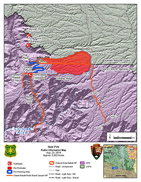
Over the next few days, the Ikes Fire will begin to right-size resources. Crews will be released from the fire as objectives are met and made available to assist with other wildfires in the country. Remaining resources will patrol and hold the fire perimeter to ensure the fire remains within the planning area. The fire has spread across approximately 5,932 acres within the 7,785-acre planning area, and has 61 resources assigned.
One objective of the Incident Management Team is to allow fire to move through the 7,785-acre planning area for resource benefit. Naturally-ignited wildland fires play an important role in fire-adapted ecosystems by reducing dead wood accumulations to ash and releasing nutrients that stimulate new plant growth, and helping to regulate insect and disease levels. These fires also create a mosaic of burned and unburned vegetation, which increases habitat diversity and breaks up continuous fuels on the forest floor (branches, fallen trees, etc.) which can help limit or slow the intensity and spread of large wildfires in the future. The Ikes Fire poses no danger to structures or local infrastructure.
Predicted forecast for Friday and Saturday is generally dry with slightly cooler temperatures and breezy conditions. Temperatures will begin to warm back up as we move into next week. There is no rain predicted in the near future.
Smoke from the Ikes Fire, along with other fires in the area, will be visible throughout the area and may cause smoke impacts. Visitors traveling to the area should be aware of possible smoke along State Highway 67. Visitors are asked to drive carefully and turn headlights on for safety. It is recommended that anyone with sensitivity to smoke limit their time outdoors when smoke is present. For local air quality and related information, please visit the following websites: http://www.airnow.gov or the Smoke Management Division of the Arizona Department of Environmental Quality.
The North Rim Village and businesses are open. However, road and trail closures are in effect for the Ikes Fire planning area for Grand Canyon National Park and the Kaibab National Forest. The following roads and trails are closed on the North Rim:
Powell Plateau Trail, The North Bass Trail, Fire Point, Swamp Point, and the W4 road north of the intersection of the W4 and W1 Roads.
The Ikes Fire poses no danger to structures or local infrastructure.
Please visit https://www.nps.gov/g rca/learn/management/firemanagement.htm for additional information about wildland fire at Grand Canyon National Park or call 928-638-7819 for recorded fire information. For additional information about the Ikes fire, visit https://inciweb.nwcg.gov/i ncident/6475/.
For fire information on the Kaibab National Forest, visithttp:// www.fs.usda.gov/kaibab or @KaibabNF on Facebook and Twitter or call (928) 635-8311 for recorded fire information. back...